
People looking for a decent detailed Greece map on the net that we decided rather then to keep apologizing because we did not know where to find one we would put one on our site. Finding a map of Greece simple enough yet with enough information to be helpful was tough but I finally found one.
Greece is located in southern Europe that you will see in Greece map below, Greece forms an irregular-shaped peninsula in the Mediterranean with two additional large peninsulas projecting from it: The Halkidiki and the Peloponnese. The Greek islands are generally subdivided into two groups, according to location:
Below is a Google map of Greece on which we’ve highlighted the most well-known Greece main cities, towns, areas and Greek islands using the pointers – click on a pointer for an explanation and to be able to click through for more information about that place. Don’t forget to drag the map around and zoom in to see more details. Alternatively, take a look at our static Greece map.
Greece Map Google
Greece is located at the most southerly part of the Balkan peninsula that you will see our Greece map and the south east of the Mediterranean sea. From the north Greece borders with Albania and Bulgaria. From the east it borders with the European part of Turkey. To the west of Greece is the Ionian Sea and to the east is the Aegean Sea. To the south is the Libyan Sea ,see more information about the Geography of Greece about the lakes, rivers and mountains of Greece ,details of the geomorphology of Greece you can find at the Physical map of Greece. The coast line of Greece is 13,676 km therefore having a the longer coastline in the Mediterranean. Most of the Greek islands and islets situated in the Aegean sea, while a small number of islands are in the Ionian Sea.
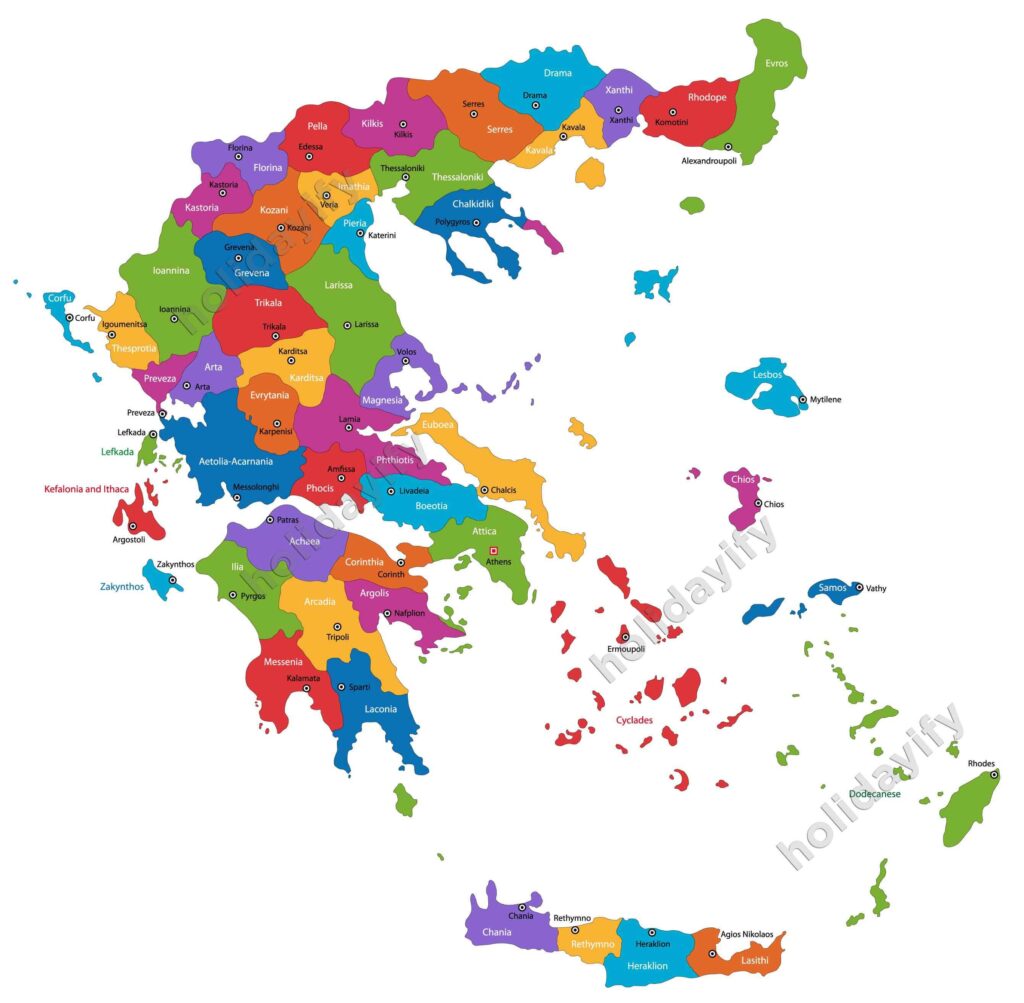
Greece Main Cities Map
Surrounded by the Mediterranean sea in 3 parts Greece has as a result a mild climate with dry summers and mild winters. Greece’s strategic position between 3 continents Europe, Asia and Africa had as a result since the Antiquity to become an important cultural and commercial centre. This strategic position was also the cause of many wars that Greece has to face with many conquerors during its 3000 years of history, starting with the Persian wars, the Romans and later the Venetians and the Ottomans.
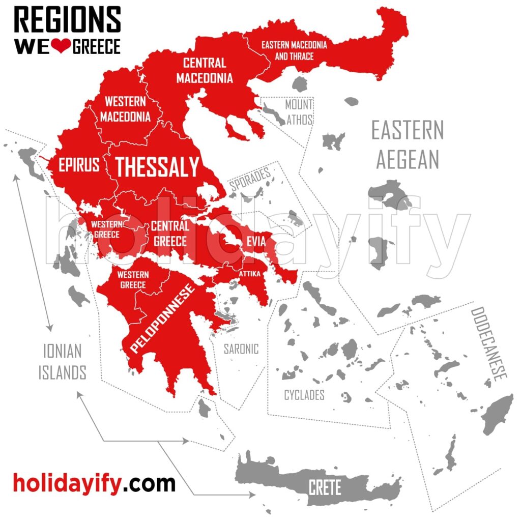
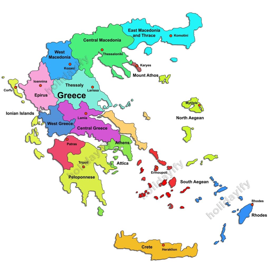
Greece is divided into 15 regions or peripheries which you will see our Greece map below. East and West Macedonia with Thrace in the north and north west ,Epirus in the north west with Thesally and Sterea Ellas with Evia in the centre ,the Peloponesse in the south, the Ionian islands in the west and the Aegean islands (Cyclades , Dodecanesse) with the north Aegean islands in the east and north east. At the southern tip lies the largest island of Greece Crete see more at the Political Greece map. Details of the historical cities and areas of Greece you can find at the map of Ancient Greece.
Regions of Greece
- Thrace
- Macedonia
- Epirus
- Thessaly
- Western Greece
- Central Greece / Sterea
- Peloponnese
- Evia and Attica
- Sporades Islands
- Saronic Islands
- Ionian Islands
- Eastern Aegean Islands
- Cyclades Islands
- Dodecanese Islands
- Crete Island
Greece in general is not dense inhabited, with a total surface of 132 000 sq.km, Greece has a population of about 11,000,000 inhabitants. The reason for that is that most of the Greek mainland is mountainous with a few plateaus in Thessaly, Macedonia and Thrace and a large part of the country consists of islands. Therefore most of the population of Greece is concentrated in the big urban centres with Athens and its greater area and Piraeus to have the one third of the Greek population followed by Thessaloniki, Patras, Heraklion and Larissa.
Greece is relatively a young country that was created after the war of Independence in 1821. The independent state of Greece was established in 1832 with the Constantinople treaty. Greece at the time had the Peloponnesus, the Cyclades and Sporades islands and the part of Sterea Hellas from Arta to Volos. After almost 116 years finally Greece got its final shape and borders after the unification of the Dodecanese in 7th of March 1948.
During the last 25 years Greece has been developed very fast in all kind of sectors, industry, finance, social services and quality of life. As a member of the European union Greece today with a GDP of 308,7 billion $, belongs to the 25 high income countries( OECD) and the top 25 most developed countries of the world, holding the position 22 of the best standards of living and quality of life. One of the main factors of the Greek economy is like in the Ancient years its maritime industry and tourism.
Greece Regions


